Download the course files in GPX format. This can be used with most navigation products and Google Earth.
100-Miler: 100-Mile - Full Course || Leg 1 | Leg 2 | Leg 3 | Leg 4 (NEW!) | Leg 5 (NEW!) | Leg 6 | Leg 7
50-Miler: 50-Mile - Full Course || 50mi Start | Leg 5 | Leg 6 | Leg 7
50k: 50k - Full Course || 50k Legs 1-2 | Leg 3
CAUTION: If you choose to explore using this information, you do so at your own risk. These files are for reference only. Portions of the Sinister 7 Ultra course cross private land and we ask that you respect the owners. Do not enter land that is marked as private.
Opens in new window:
All distances and elevations have been verified by GPS at maximum 10m point intervals, as per ITRA standards. Difficulty is based on how hard the leg is in comparison to the other legs of the race, in our opinion (ie: Leg 6 is 7/7 meaning it is the hardest). Every leg of the race is hard.
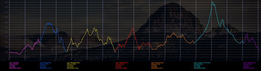
Distances: 161km/100mi (100-Miler)
82.9km/51.5mi (50-Miler)
50.1km/31.13mi (50k)
Elevation: 6407m / 6354m (100-Miler)
2985m / 2951m (50-Miler)
2255m / 2255m (50k)
Duration: 100-Mile = 30 hours to complete the course
50-mile = 24 hours to complete the course
50k = 13.5 hours to complete the course
Distance: 18.3km
Gain: 535m
Loss: 344m
Max Elevation: 1562m
CPs*: CP1a - 8.3km/ CP1b - 13.25km
Difficulty: 2/7
Trail Type: Paved road, gravel road, double track, single track
Est Time: 1 to 3.5 hours
Must Start: 07:00 hrs (Saturday)
Cutoff: 10:45 hrs (Saturday)
The first leg of the Sinister 7 crosses the massive debris field of the Frank Slide. Spread over several kilometers, the slide consists of rocks and boulders as large as houses. Experts say the mountain will fall again one day; maybe tomorrow, next week, or next year... After the Slide, the route passes through the town of Hillcrest and through Bear Valley to the base of Hastings Ridge.
Distance: 19.3km
Gain: 870m
Loss: 870m
Max Elevation: 1800m
CPs*: CP1a - 8.3km/ CP2 - 12.8km
Difficulty: 3/7
Trail Type: Road, gravel, single track, double track
Est Time: 2 to 5 hours
Must Start: 07:30 hrs (Saturday)
Cutoff: 15:00 hrs (Saturday)
The 50k course starts right after the 100-Miler in downtown Blairmore. You run out of town and up the Drum Creek drainage to CP2 and then the infamous Heartbreak Hill. This bridges the first half of Leg 1 and the last half of Leg 2. After that, the 50k runners continue onto Leg 3.
Distance: 16.7km
Gain: 772m
Loss: 942m
Max Elevation: 1873m
CPs*: CP2 - 10km
Difficulty: 3/7
Trail Type: Single track, double track, dirt road
Est Time: 1.5 to 3 hours
Must Start: 10:45 hrs (Saturday)
Cutoff: 15:00 hrs (Saturday)
Beginning at the base of Hastings Ridge, runners begin a grueling climb to a rewarding view. Once atop the ridge, you get a view of the entire valley, including Crowsnest Mountain and the Seven Sisters; certainly worth the punishing climb to the top! There is no time for rest as runners drop down the other side and head towards Blairmore to the finish of leg two.
Distance: 30.8km
Gain: 1385m
Loss: 1385m
Max Elevation: 1776m
CPs*: CP3a - 8km/ CP3b - 17k/ CP3c - 24km
Difficulty: 6/7
Trail Type: Double track, single track, gravel road
Est Time: 3 to 5 hours
Must Start: 15:00 hrs (Saturday)
Cutoff: 20:00 hrs (Saturday)
Also known as "Satan's Sack", Leg 3 is dry, hot, and exposed. This leg of the Sinister 7 has the second most elevation gain and distance. In return, you are rewarded with stunning views of the mountains atop the Continental Divide! This leg crosses through the haunting remains of the 2003 Lost Creek fire where one feels as though they are on another planet. After passing the burn scar, runners once again climb back into Blairmore for the start of leg 4.
Distance: 25km
Gain: 1032m
Loss: 986m
Max Elevation: 1809m
CPs*: CP4a - 6.5km/ CP4b - 15.5km
Difficulty: 5/7
Trail Type: Single track, double track
Est Time: 2.5 to 5 hours
Must Start: 20:00 hrs (Saturday)
Cutoff: 02:00 hrs (Sunday)
Leg 4 throws it all at you; tough climbs, water crossings, rugged ground and some fast trail! Straight out of the gate we welcome you with a climb half way up the ski hill. While gasping for air, remember to check out the beautiful views with some great photo opportunities.
Distance: 13.9km
Gain: 302m
Loss: 254m
Max Elevation: 1486m
CPs*:
Difficulty: 2/7
Trail Type: Single track, double track
Est Time: 1 to 3 hours
Must Start: 10:30 hrs (Saturday)
Cutoff: 10:30 hrs (Sunday)
The 50-Miler starts from west Coleman and connects into leg 4. You miss the climb up Big Bear, but this leg is fast and runnable to spread you out. Note that there is a wee bit of single track about 1km after the start, so find your position early. Do you even want to stop at the aid station? After TA4 you connect with the rest of the course - Legs 5 through 7.
Distance: 26.2km
Gain: 962m
Loss: 856m
Max Elevation: 1677m
CPs*: CP5a - 8.5km/ CP5b - 20k
Difficulty: 4/7
Trail Type: Single track, double track, dirt road, paved road
Est Time: 3 to 5 hours
Must Start: 02:00 hrs (Sunday)
Cutoff: 06:00 hrs (Sunday)
Leg 5 presents some good old classic cross-country running. Connecting runners from the south end of the course to the north end, this leg presents you with a great cross-country style run alongside Mt. Tecumseh. You can guarantee to be hit with big gnarly roots, water crossings, mud holes and just enough climbs and descents to leave you begging for it to finish!
Distance: 31.9km
Gain: 1400m
Loss: 1400m
Max Elevation: 2292m
CPs*: CP6a - 8km/ CP6b - 17km/ CP6c - 24.5km
Difficulty: 7/7
Trail Type: Double track, single track, high alpine, dirt road
Est Time: 3.5 to 7 hours
Must Start: 06:00 hrs (Sunday)
Cutoff: 12:00 hrs (Sunday)
This Leg will try the toughest of racers. This route takes runners through some of the most remote terrain on the course as they make their way to the evil climb north of Seven Sisters Mountain. While catching your breath at the highest point on the course, don't forget to check out some of the larger mountains in the area: Crowsnest to the south as well as Tornado and Gould Dome to the north. There is no time for rest as runners drop to the west and make their way around the base of Crowsnest Mountain along trails and numerous drainages. Sure footing is key on this section as you round the southern edge of the mountain and arrive back at the McGillivray staging area to begin the final leg of the race.
Distance: 10.9km
Gain: 321m
Loss: 441m
Max Elevation: 1666m
CPs*: CP7 - 5km
Difficulty: 1/7
Trail Type: Dirt road, single track, double track, paved road
Est Time: 1 to 2 hours
Must Start: 12:00 hrs (Sunday)
Cutoff: 13:00 hrs (Sunday)
The final leg begins with a steep, ugly climb up the base of Wedge Mountain, followed by an incredible single track descent into the Nez Pierce Creek valley. Following another single track trail along the western slopes of Saskatoon Mountain, runners emerge in north Coleman. Be sure to save some energy for the last push to the finish line!
*Distance to CPs accurate to within 500m.


©2020-2023 Sinister Sports Inc. All Rights Reserved.


